Sunday, August 31, 2008

"Avoiding the touch"

In contrast to the dramatic incidences on Nevado Pisco in Peru, I had a rather uneventful climb up Huayna Potosi, a 6088m (19,974 feet... just 26 feet under 20,000! grrrr) peak in Bolivia's Cordillera Real. Huayna Potosi is a popular climb, dubbed the easiest 6,000m climb in the world. The base camp is at about 4,700m and a refuge at about 5,300m. You could probably camp on the snow, but it is really, really cold.

I honestly thought I would suffer a lot more up Huayna Potosi, as I was having difficulty getting enough oxygen into my lungs at 5,300m on Nevado Pisco. The conditions on Huayna Potosi were great, however, and I didn't suffer (perhaps to my disappointment...), feeling great during the entire climb. I think I've gotten in much better shape since Pisco, too, and gotten more adjusted to the +3,700m altitutde. On the way down, I offered to carry some of my fellow climber's gear, almost feeling sad that the mountain hadn't pushed me to my limits -- and that I hadn't "touched the void."

It's a relaxing 3 hour hike up to the refuge from the base camp, which includes a lovely refuge complete with hot showers and a fireplace. I think it can easily be done in 2 hours, but our guides seemed to insist that we were all whimps and needed frequent breaks. We didn't have any donkeys, which I suppose made it a much more "pure" climb, and I carried all my equipment -- plastic boots, two ice axes (only one was necessary, however), crampons, harness, three liters of water -- up to the refuge at 5,300m.

At the refuge at 5,300m, the night before the ascent. The view was incredible.


At the refuge on the glacier, we melt some snow for a warm tea before setting off at 3 am for the summit. Two guides accompanied two Israelis, an Englishwoman, and myself. We heard it was a four to five hour climb, and we managed it in almost exactly four hours, summiting at 7:08. The climb wasn't technical at all: the only two parts that necessitated ice axe usage were a 50 degree ice wall at about 5,700m, and then a narrow ridge about 30m before the summit. Unfortunately for me, a lefty, this required using the ice axe in my right hand. Although my right arm is more or less as strong as my left, it was a bit like trying to play tennis with my right arm -- each ice axe strike was a pathetic mis-hit on the ice.

Ok, so the two Israelis were smart enough to make summit posters before the climb, and I had to take a picture with one of them. This one apparently says "I love you mom" (I love you mom! And happy birthday tomorrow!) in Hebrew. Tal, the one who made this poster, is to my left. Tal didn't seem to be in great shape, but was definitely determined: he had been sick for the past day and vomited five times on the climb.

Don't worry, this won't become a mountain climbing blog, as I'm about to head out of the Andes and into the eastern part of South America -- Paraguay.

Bolivian update

I'm on my way to my next destination on the Watson Fellowship -- Ciudad del Este, Paraguay -- and am transiting through Bolivia. Most travellers I met in Peru raved about Bolivia: the landscapes, the people, and of course, the prices. Nevertheless, there are far fewer U.S. Americans in Bolivia than in Peru, perhaps because of the recent $135 USD visa fee slapped on all (and only) US residents.

At any rate, because I am spending so little time here, I will offer only the most superficial observations.

1. The Bolivian navy on Lake Titicaca. Bolivia has a navy, which is slightly ironic considering Bolivia is a landlocked country (one of only two in South America, the other being Paraguay). I noticed this on Lake Titicaca, which is shared by Peru and Bolivia, and at 3900m, is supposed to be the highest navigable lake in the world.

2. The one chifa I went to in La Paz was an artist's residence rented out to be a Chinese restaurant, which apparently in two years time, will become an art museum. For now, however, it's just a chifa.

3. Evo Morales. Bolivia's first indigenous president seems to have a lot of support in the La Paz region -- everywhere there are political slogans painted on buildings supporting "Evo" and his political party, the "Movement toward socialism."

4. Llama fetuses. On the street where I am staying in La Paz there seems to be a proliferation of herbal medicinal remedies, which include different kinds of alcohol as well as llama fetuses hanging from the ceiling. Apparently people sacrifice them here in homage to Pachamama, a goddess in Aymara and Quechuan cultures here in the Andes.

Sunday, August 24, 2008

Ciao, Peru!

I left Peru for good today, making my way to Bolivia along Lake Titicaca. Right now I'm on "Isla del Sol," or Island of the Sun, on the Bolivian side of Lake Titicaca. The lake is incredibly large -- the islands remind me a bit of the Greek islands in the Mediterranean Adriatic.

That's it for now.

Monday, August 18, 2008

Cell phone drama

So I've been using a Motorola Tri-band GSM phone I bought two years ago in Beijing. The main reason I bought it was so that I could use it in other countries -- simply swapping SIM chips in and out of it whenever I go to new countries. I've now collected SIM chips from China, India, South Africa, and now Peru.

Unfortunately, in all the aforementioned countries (with the notable exception of China), using cell phones is prohibitively expensive. As a result, most people send short text messages, which are far cheaper. An additional bonus to text messages, especially when service is a bit dodgy, is that communication is always clear. No constant "what? what?" as the other person descends into static.

I had already blown through about $10 USD worth of cell phone credit in my first week in Peru, so I tried to send mostly text messages. Unfortunately, I began to realize that my text messages were not sending when nobody was replying -- I checked the status of about ten text messages and saw that it just said "sending in progress." I was able to receive text messages but not able to send them. I gave up on text messages for the next couple weeks in Lima.

After turning off my cell phone during my time in Huaraz, and coming back to Lima, my cell phone magically discovered how to send text messages. As a result, about ten text messages were sent all at once, their contents no longer relevant. Examples:

"Good I'm in front of the office waiting for you"

"Dinner? I'm interested in the Quito move" (a response to a friend that had contemplated moving to Quito, Ecuador)

"Are we going to meet in the school?"

"Come to Miraflores for ceviche"

"I'm on Avenida la Marina I'm coming now"

"What was the name of the place we went to last night and where is it?"

As you may suspect, these messages were no longer relevant three or four weeks after I had originally intended to send them.

The replies I got were funny:

One called me three times before sending me an email asking me why I was bothering them.

Another responded "it's called Sargeant Pepper's let's go tonight" (in response to the last text; I know for a fact it was not Sargeant Pepper's, but I appreciated the reply regardless)

To "Let's meet at the school," the response was a curt, "I'm at work."

Thanks Mr. Thomas J. Watson

Due to the declining value of the dollar, the Watson Fellowship office has just sent an email saying that all fellows will get a one-time $3,000 supplement to their original stipend.

YESSSSSSS.

Machu Picchu

Going to Machu Picchu is a pilgrimmage, of sorts; one guidebook states that nearly nine out of ten visitors to Peru make it to Machu Picchu. I kept reading that all the glossy photos of Machu Picchu can't live up to the real thing.

I'll have to agree. Perhaps even more amazing, as I spent more time in Machu Picchu, hiking along various Incan trails, I began to appreciate it in new ways: the intricate stonework, the careful terracing of the mountains, the integration of manmade architecture into the natural landscape.

Most people are surprised to find out that the Incan site was "discovered" in 1911, quite recent, really. What I find more amazing is that the Spanish never got to it during centuries of colonialism. The American archaeologist who discovered Machu Picchu, Hiram Bingham, apparently had all these fantastical ideas that it was the lost city of the Incas, that it was where the Incans fled to when the Spanish defeated them. He thought all sorts of virgin sacrifices and things took place; now, most archaeologists agree that the site was simply a summer retreat for Incan royalty.

I should say that this past week I was very lucky to have two visitors from home come visit me: two friends from high school (actually, long before that), Kailin and Carl -- who are now slaving away at the Federal Reserve Banks in New York and Boston, respectively (but with incomes far larger than any grant from a fellowship institution). Given their short time here, it seemed to make perfect sense to make our peregrination to Machu Picchu this week.

We took various public buses from Cusco to Ollantaytambo, the last town accessible by public roads before Machu Picchu, and then the backpacker train from Ollantaytambo to Aguas Calientes, the town just below the heights of Machu Picchu.

We woke up early to watch the sunrise on Machu Picchu, but could hardly enjoy it in the mass of fog and the scramble among the other tourists for the best view. Surprisingly, we were among the first 400 tourists to arrive there that day (which gives you an idea of the thousands of tourists that arrive there everyday), which meant that we got passes to climb Huayna Picchu, that big mountain in the background of all the Machu Picchu photos. The park has realized that the thousands of tourists are causing quite a bit of erosion, so they only allow the first 400 people onto Huayna Picchu.


Huayna Picchu is that big thing in the background. Admittedly, this photo was taken just before the park closed at 5:30 pm, because the mountain was completely obscured at sunrise. Witness:


The big story of the climb was that Carl got massively dehydrated on the climb to Huayna Picchu. In my excitement, I told Kailin and Carl they got each have a third of my liter of water, after both had finished their 750ml of water -- instead of going back to the entrance and buying $3 bottles of water (normally it costs about $0.30... everything in Machu Picchu is about 10 times the price it should be). At any rate, we made it and took glorious photos of our summit.


Carl is in the middle, obviously too dehydrated for a real smile. I felt like taking off my shoes at the summit.

Although the view from Huayna Picchu wasn't the most beautiful, it gave a completely different perspective of Machu Picchu. The integration of Machu Picchu's architecture into the mountain landscape came into full relief.


The sweaty author and Machu Picchu in the background. The smaller peak is in the lower right of the photo. I have to say, I think I must be in some of the best shape of my life, I feel great climbing at over 3,000 meters. It's all downhill from here.

Since the sunrise was a little disappointing, I took photos of llamas instead.


Bye!

Sunday, August 10, 2008

"Touching the void" (updated with photos)

This fellowship has kept me quite busy since I began this journey a little more than a month ago. Sure, it is all one big personal vacation, but occasionally one gets the urge to do other things besides explore Chinatowns. Urban adventures begin to wear on the bones. Unfortunately, this job has kept me pinned to the Chifa and the vegetable markets. So, in order to explore something completely different, I had to send out a friend of mine (who shall remain anonymous at his request) into the Peruvian Andes, the fabled Cordillera Blanca.

What follows is tale of mountaineering adventure -- of snowed-over crevasses, breathtaking ascents, avalanches, blinding blizzards, of monumental ice walls. Lost at the summit for five hours in white-out conditions.
I'm taking this title from the book "Touching the Void, a book/film about a disastrous descent from Siula Grande, also in the Peruvian Andes. You can actually watch the entire movie off Youtube, in twelve segments, starting here. My friend recounted the entire climb in excruciating detail, and I'm going to try to whittle it down to get at the most interesting parts. So here goes his story.


The mountain

Nevado Pisco is a mountain in the Cordillera Blanca, about 60 km north of Huaraz, which is about 400 km northeast of Lima. Huaraz is reachable by bus, which takes about eight hours.

At 5,760 meters above sea level (or about 18,900 feet), the mountain is significant in size yet climbable without taking lots of expedition gear.
The mountain can be climbed in one push; it takes about ten hours of normal-paced climbing. Most people, however, stay at the base camp at about 4,600 meters, and there is a second moraine camp in a moraine field at about 4,900 m or so, about 3 hours from the base camp. The moraine camp is not accessible by donkeys and has no fresh water, so it is mainly used by those who require two nights for the climb. The glaciers begin at about 5,000 m or so, and from then on its about a five or six hour climb to the summit in the snow.

In the past, the mountain has presented few technically difficult sections, with only a few crevasses to negotiate and a short ice wall. The Andes range (which is the second largest range after the Himalayas) has apparently bore the brunt of global warming, however, and there are many disturbing photos and signs that the glaciers are fast retreating. Glaciers have broken away and now there is a significant 50m ice wall to climb before summiting. Conditions on the mountains are always somewhat unpredictable, but guides seem to acknowledge that many mountains in the Cordillera Blanca are changing rapidly and unpredictably.


(From Google images)

Motivations
I had never climbed a major mountain, and Pisco presented the perfect opportunity. It required little technical skill, and could easily be done in two days. Even though hiring a guide for climbing was significantly more expensive than for trekking, I knew I wanted the experience, at least once, of climbing a mountain.


Before the climb I tried to acclimatize myself by hiking up maybe 500 meters above Huaraz in the canyons for about 3 hours. The day before the climb I went mountain biking, climbing about 850m over 10 km in about an hour... a steep grade of about 8.5%! The mountain biking was tough, but at least got my heart pumping for an hour before about a 3 hour descent through little Andean villages.


Day One: Base camp (4,600m)
We set out from Huaraz at about 8 am in a station wagon loaded with gear, mostly food and cooking stuff. There were four of us: Victor, our guide; John, a New Zealander now residing in California; Roosevelt, our cook and porter; and myself, a Gringo. The car ride took about an hour and a half, crossing into Huascaran National Park.

We were dropped off at about 3,900 m in the "cebollapampa" (high altitude grasslands?), and climbed the 700m or so for about two hours to the base camp, arriving before 1 pm. To my surprise, we used three donkeys to carry up all of the cooking equipment and tents, so I only had to carry a day pack. We spend the day milling around the base camp, setting up our tents, anticipating the climb ahead of us.


My tiny one-person tent at the base camp! My ice axe sits majestically at its side.


Roosevelt sets up a cooking tent and prepares fried chicken for dinner. A Norwegian expedition team is headed back down from the base camp; apparently one of the guys got sick from the water there. Pisco is a popular acclimatisation climb for higher peaks in the Cordillera Blanca, so there is a mix of professional and amateur mountaineers.

We try to go to bed early, at around 8 pm, but I have an upset stomach the entire night and only manage to sleep for maybe half an hour at most by the time our guide wakes us up at 12:50 am.

Day Two: Summit (5,760m)

1:40 am, 4,600 m. The three of us -- Victor (guide), John (Kiwi, fellow climber), and myself -- set off from the base camp after a breakfast of toast, yogurt, and tea. I am carrying cramp-ons, an ice axe, harness, two liters of water, some snacks, a down jacket, sunglasses.

It is dark, and we begin climbing up a moraine field illuminated with our headlamps. It is quiet and cold, nobody talks, the only sounds are the sounds of our steps and breathing. Up ahead we see two faint lights high above: Victor tells us it must be climbers leaving from the moraine camp 300 m up.

3:45 am. around 5000m. We reach the the edge of the glacier. For the past hour or so, we see two headlamps working their way closer to us, it must be the Austrian team climbing for acclimatisation for a tougher peak. When we reach the glacier, we begin putting on our equipment -- harnesses, crampons, rope, ice axes in hand -- I put on my down jacket as it has gotten significantly colder. The Austrian team leaves before we do, climbing at a quick pace.

6:00 am. Sunrise on the glaciers. It begins to get light out and we turn off our headlamps. The wind is quite strong and it is snowing lightly. We can't see the sun through the clouds, and the altitude is finally beginning to take its toll on my lungs. Five steps up the mountain and my heart is pounding. I try to breathe but feel like I'm not getting anything in.

9:05 am. Summit! At 5,760m (or thereabouts) we push through the last two final challenges. The last climb we face is a nearly-vertical ice wall, maybe 50m high. Victor climbs it first, then attaches our harness to a pulley at the top. I scale the ice wall trying to do it in one go, digging my crampons and axe into the ice, trying not to lose momentum. After I reach the summit, I collapse from exhaustion and to catch my breath. When I am able to get up, John has already scaled the summit and collapses. We all embrace each other.


At the summit. Visibility is very poor. Can't seem to rotate images in blogger or on the computer.

Reaching the summit is a feeling of elation, exhaustion, relief, adrenaline, all wrapped up into one. At once I am too tired to comprehend all the physical exertion I've put into reaching this point. It is quiet, it is completely white. We can't see anything; occasionally we catch a glimpse of nearby mountains, but they quickly fade into the clouds and the snow.

9:30 am. We begin to make our way down. John first, me second, Victor last. We can make out a few tracks, but it is difficult in the white-out conditions. The footprints fade and after descending about 100 or 200 m, we realize that we must have taken the wrong route.

10 am. We continue to try new paths to try to get back on track. The snow continues to come down, and it is impossible to distinguish between cloud and mountain. It is all white: directionless, contourless.

11 am. Victor thinks he knows a way out. We rappel down a glacier about 50m. We begin to walk around and see footprints. We follow the footprints to the right.

11:30 am. The footprints to the right lead nowhere, useless. We turn around.
12:00 pm. We go back the other direction, but it also leads nowhere. We have to climb the ice wall we just descended. Another ice wall to scale for the mistake we made.


John leads the way on another unsuccessful descent.


12:00-1:30pm. We continue to try different paths. At one point we begin walking and the snow begins to sink quickly. Victor realizes this is avalanche territory, and we hurry back in the other direction. He advises we climb about 50-60m and skirt the avalanche.

1:30-2:30pm. Continue to be lost, continue to try to find a path out. I am dehydrated, exhausted, falling asleep in the snow. Worried.
John suggests building a snow shelter until the weather improves.
I tell Victor that I have to conserve my energy and that I can't waste any more time on dead-end climbs. Climbing at over 5,500m drains my energy and I simply can't keep climbing unless I know that it'll lead to a safe descent.

2:35 pm. Clouds clear for less than a minute, but Victor finally sees the correct path down. We are all somewhat skeptical, but also feel relieved to know that this might finally lead to a safe descent.

2:45 pm. This is the way down. We follow a long trail down the glaciers.

3:00 pm. John slips into the snow. I had slipped numerous times, but this was the first time he does. A snowed-over crevasse is the culprit: John manages to stop himself with the ice-axe (and perhaps long legs), so I don't feel the tug on my harness as he slips.

We continue descending rapidly down the glacier, I feel the muscles tense in my knees but am at least not breathless. At times, we are practically sliding down the mountains. The powder is thick and I am constantly cleaning my crampons.

4:15 pm. Off the glaciers at last. It is such a relief to get onto the moraine, even though it is probably more painful to descend, but it feels great to get off the snow and glaciers, after over twelve hours in the snow.

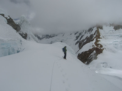
At the edge of the glacier; off with the crampons. Happy.

5:30 pm. Stumble back to the base camp. Relieved, dehydrated, sunburnt, exhausted.

Day Three: Back to Huaraz.

We have a late breakfast and pack up the tents and the donkeys at about 10 am.

Going down, we see others going up to the base camp. Eager, anticipated faces. Shaven faces, sharp and determined. We are exhausted going down, lips chapped and swollen, our bodies dirty and foul-smelling.

When I ring the doorbell at the hostel, the normally quiet hostel-owner remarks, "Bad weather recently, eh?"

Friday, August 8, 2008

A few photos

So I realize that I haven't posted any photos of Chinatown streets or the big gate here in Lima. Part of the reason why I haven't is because those kinds of photos are readily available on the internet, and my photographic contributions aren't new or original. But maybe I've been spoiled, because I get to see these streets everyday.


Vegetable market


Calle Capon, the main drag:

Saturday, August 2, 2008

Panyu Ancestral Temple 番禹会馆 Lima, Peru

Continuing on the same theme of "ancestral temples" as the previous post, I had a chance to attend another temple gathering within Barrio Chino. This was at the Panyu temple, which is supposedly based around clans and kinships from Guangzhou City (广州市).

This gathering was held on Monday, the day before Peruvian independence. A lion dance was held outside and made its way inside.


Throughout a hallway and within a special room were photos of the original immigrants from Guangzhou.